
 While going through some of my research papers stored in a filing cabinet I came across some interesting research I completed twelve years ago. During 1992 I invested several weeks tediously researching the Chickasaw Cession surveyors’ notes for Itawamba County. Located in the Chancery Court Clerk’s office, this large volume of several hundred pages contains the field notes and observations of the government surveyors for the Chickasaw Cession area that eventually became Itawamba County. Most all the notes are surveying field notes giving distances and landmarks in laying out the section, township and range system for Itawamba County. However this book also offers the researcher a description of the land (hilly, flat, swamp, what types of vegetation etc.).
 Another most interesting feature of the book’s records is whenever the surveyors came across any type of improvement upon the lands they were surveying, these improvements were usually documented.
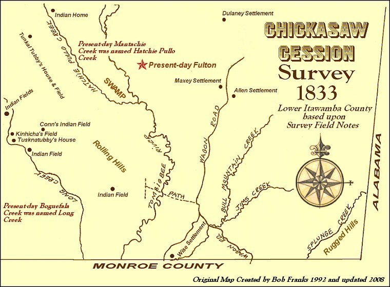
After consuming several weeks tediously reading over the hundreds of pages of detailed notes, I compiled an inventory of all improvements denoted that I found and then created a map of current Itawamba County illustrating the improvements seen by the government surveyors during 1833 – three years before the county was officially created..
It is interesting to note that all the Chickasaw improvements I came across in the notes were west of the Tombigbee River with a significant concentration of such improvements in the Mantachie, Ozark, Ratliff and Kirkville areas (basically northwestern Itawamba County). In this area of Itawamba County were references to many Chickasaw paths and trails. One such trail connected the Natchez Trace to the present-day area of the town of Mantachie. There were also several Chickasaw improvements noted along present-day Boguefala Creek in southwestern Itawamba County. On the other hand, all improvements I discovered representing early pioneers were east of the Tombigbee basically along two wagon roads entering Itawamba County from adjacent Monroe County . These two roads merged into one single road not far into Itawamba County, north of Bull Mountain Creek.
Also of interest in the notes were the names of some creeks. Present-day Mantachie Creek was listed as Hatchie-Pullo Creek and Boguefala Creek was listed as Long Creek. I have published online a portion of the map I created illustrating the part of the cession that became lower Itawamba County (view the map). I plan to publish online a similar map for upper Itawamba County at a later date.


No comments:
Post a Comment