
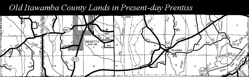
 Above is a detail from Itawamba County Range Book 8 Volume 1 housed in the Itawamba County Chancery Court Clerk’s office in Fulton showing land records of the present-day Marietta area of Prentiss County. This is just one illustration of areas currently in other counties that were once a part of old Itawamba County. In researching old Itawamba County families don’t forget that over the years, lands in Itawamba County were transferred to three different counties – Tishomingo, Prentiss and Lee. An ancestor who disappears may be found in these counties at a later date and ancestors in those three other counties may be found in old Itawamba County at an earlier date. When Itawamba County was organized the law creating the county described the boundaries as:
Beginning at the point where the line between townships six and seven intersecting the eastern boundary line of the state, and running thence with the said boundary line, to a point one mile north of its intersection with the line between townships eleven and twelve; thence due west to the line between ranges five and six east; thence north with the said range line, to the line between townships six and seven, and thence east with the said township line, to the beginning, shall form a new county, and be called the county of Itawamba.
Lee County, formerly embraced within the limits of Itawamba and Pontotoc counties, was established October 26, 1866 with the largest portion of its land coming from Itawamba County (a strip ten miles wide off western Itawamba County, from north to south). The old Itawamba lands east of the line between Ranges 5 and Ranges 6 (old Itawamba-Pontotoc county line) for ten miles went to the new county. This included many old Itawamba County towns such as Baldwyn, Guntown, Saltillo, Tupelo, Verona and Shannon. Most of Lee County today is composed of old Itawamba County territory.
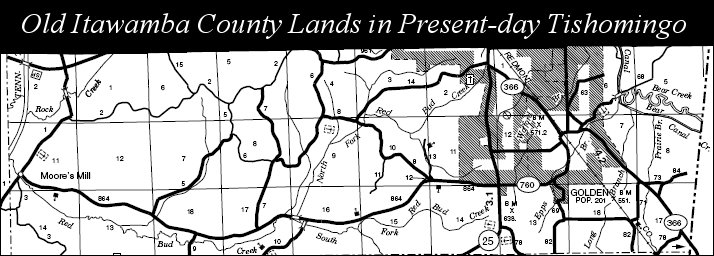
On April 15, 1870, Tishomingo County was split into three counties – Alcorn, Prentiss and Tishomingo. At this time a strip running east to west three miles wide along the northern border of Itawamba went to the counties of Tishomingo and Prentiss. The former Itawamba County lands going to Tishomingo County included thirty square miles (a strip ten miles wide and three miles deep - see map). The former Itawamba County lands going to Prentiss County included thirty-six square miles (a strip 12 miles wide and 3 miles deep - see map).
As a result of these boundary changes the researcher should remember county and census records for parts of present-day Tishomingo and Prentiss (such places as Marietta, Golden, Moore’s Mill) are found in Itawamba County prior to April of 1870 and county and census records of nearly the eastern two-thirds of Lee County are found in Itawamba County prior to October of 1866.


1 comment:
Thanks, Bob, for posting this information. Although I knew that the boundaries changed, the details were not known to me, so this is a big help. As you know, the Millses and McKays hugged the Itawamba-Prentiss-Tishomingo area while my Robinsons et al hugged the state line with Alabama. Nothing is simple when it comes to researchng our neck of the woods.
Post a Comment